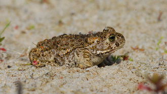
For the natterjack toad (Bufo calamita) numerous actions have been carried out on the Geest between Vechta and Damme to connect the subpopulations. © Frank Körner, Naturschutzring Dümmer e.V.
download picture
main content
Project of the month
#1/2019 DAMMER BERGE
Optimizing the habitat for the natterjack toad
Connecting two sub-populations on eight subareas in the Damme Hills
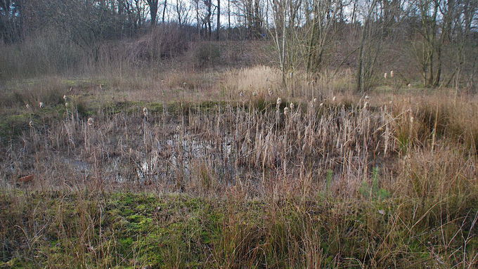
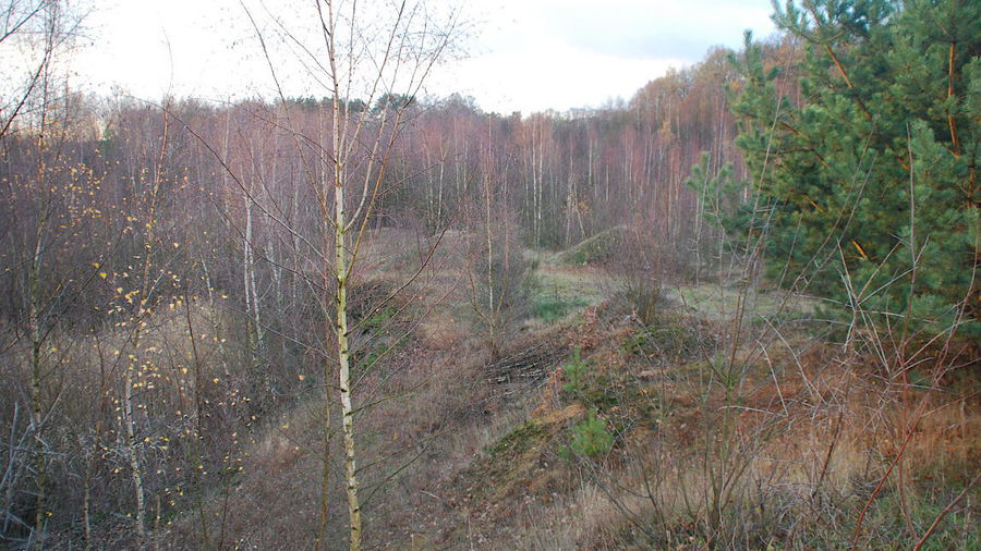
The Damme Hills and the adjacent top of the Geest northwards to Vechta have a large number of significant deposits over a length of about 25 kilometres. Sands, gravel and clay were mined here and have left behind extensive excavation sites which can offer secondary habitats to threatened endangered amphibian species such as the natterjack toad (Bufo calamita).
In a preliminary investigation in 2017 by the “Naturschutzring Dümmer” on behalf of the Lower Saxony Water Management, Coastal Defence and Nature Conservation Agency (NLWKN), thirteen sites in the region of the top of the Geest between Vechta and Damme had been assessed as (potential) habitat for the natterjack toad. The distribution pattern of the species had been recorded and a semi-quantitative assessment of the population numbers of the local populations of the natterjack toad had been made. In addition, various parameters of the terrain had been recorded in these areas. The results should not only lead to a classification of the conservation status with regard to existing populations, habitat structures and the threats to the species, but also show concrete options for action in order to improve the conservation status. The selected study sites were predominantly former or only partially operating sand pits which follow each other in the Damme Hills from north to south. The individual sites had a size between three and 15 hectares and were connected to each other at a distance of about 600 to 5,800 metres. The recording of nocturnal toads was based on the detection of callers and visual observation of adult and sub-adult individuals as well as egg strings and / or larvae in selected potential spawning waters or their surroundings.
Only in three of the thirteen studied sites toads were recorded. In only one site, the population was classified as "good" and in two sites "medium to poor". The populations were separated by three to thirteen kilometres, so that they probably had no direct exchange with each other. The conservation status of the thirteen studied sites using all criteria was evaluated as "moderate to poor". The evaluation of the threats to the species resulted in only four sites being assessed as "medium". In all other sites, the threats were considered to be "strong", particularly due to isolation by migration barriers and the distances to the next population of natterjack toads as well as a degradation of the habitat by succession.
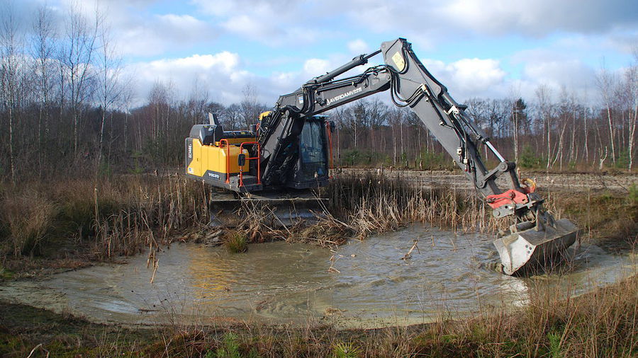
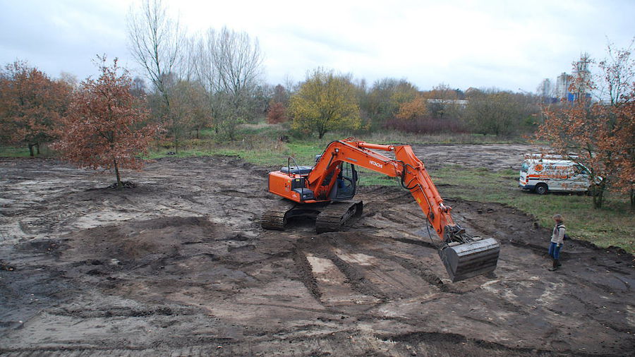
For twelve of the thirteen studied sites actions were proposed. For eight of these sites, the district of Vechta, the Dümmer Nature Conservation Centre and the NLWKN developed concrete actions for implementation within the framework of the LIFE Integrated Project "Atlantic Region DE". Four of these sites are publicly owned (by the Cities of Lohne and Damme and the district of Vechta), while the remaining four sites are located in former sand mines owned by the company Averdam. In general, the construction of sunny, partly permanently water-bearing standing waters, the maintenance of existing, partly temporary waters, the local removal of successively grown wood and the local creation of immature soils were recommended to permanently connect and stabilize the populations. The resulting open-ground areas and the treated pit areas may also be potentially suitable habitat for the sand lizard (Lacerta agilis). In addition, synergy effects for oligotrophic to mesotrophic standing waters with vegetation of the Littorelletea uniflorae and/or of the Isoeto-Nanojuncetea (3130) are to be expected.
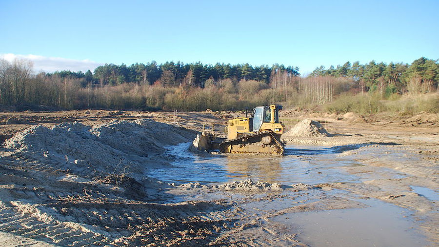
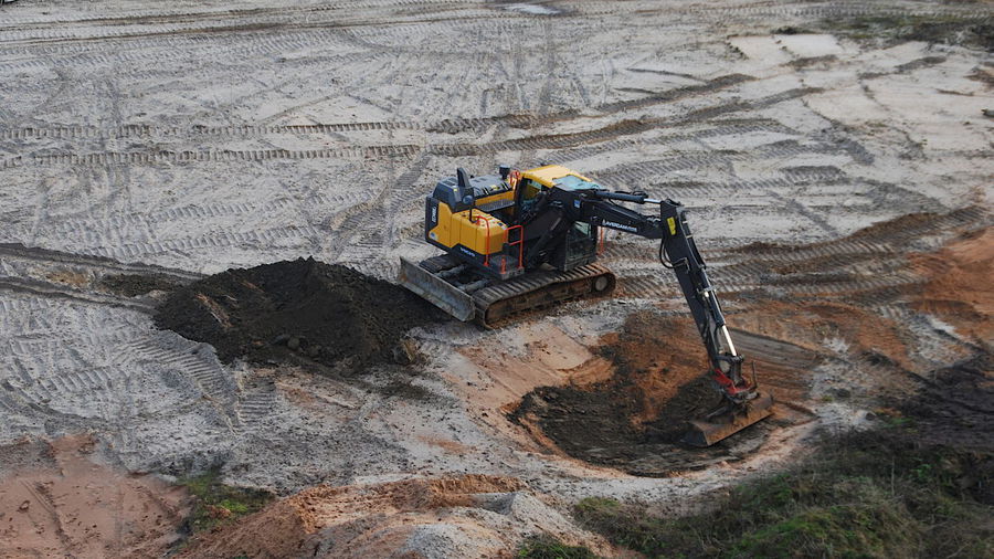
Works in the eight sites were carried out from mid November to February 2019, with the Naturschutzring Dümmer carrying out the construction supervision.
- The sand pit Tonnenmoor (owned by the company Averdam) is located south of the city of Vechta, directly east of the main road L 846 from Vechta to Lohne. The site includes a former sand-clearing area with about 20 small or very small and two larger standing waters. Fifteen temporary small standing waters as well as some permanently water-bearing small waterbodiess in sun-exposed position were restored by removing woods and bulrush. The removed shrubs and plant material were transported to designated border areas and the topsoil was subsequently stripped.
- The sand mining area Brägeler Baggersee is located northeast of the City of Lohne, on the edge of a business park. It is characterized by a larger excavated lake which is cut deep into the terrain, so that there is a height difference of more than seven metres. Small waterbodies were not available. The western adjoining areas were partly overgrown with bushes and showed an eutrophic ruderal vegetation. Nutrient-poor grassland vegetation was only present in relicts. Here, eight temporary water-bearing waterbodies have been newly created in sun-exposed positions. The surrounding woods were removed and the topsoil extensively stripped.
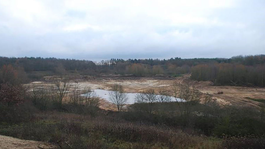
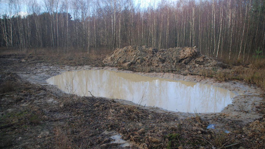
- The biotope Sandgrube Moorstraße (owned by the company Averdam) is also characterized by strong differences in height and was in an advanced stage of succession. With the end of mining in 1999/2000, a local conservation association had already created larger waterbodies with groundwater for amphibians. In this area, the woods were also extensively removed and transported to designated peripheral areas. Fourteen temporary waterbodies and a few permanently water-bearing ponds were restored or newly created, and then the topsoil stripped. Here again a large open sand area has developed which has many structures for amphibians and other endangered animal and plant species.
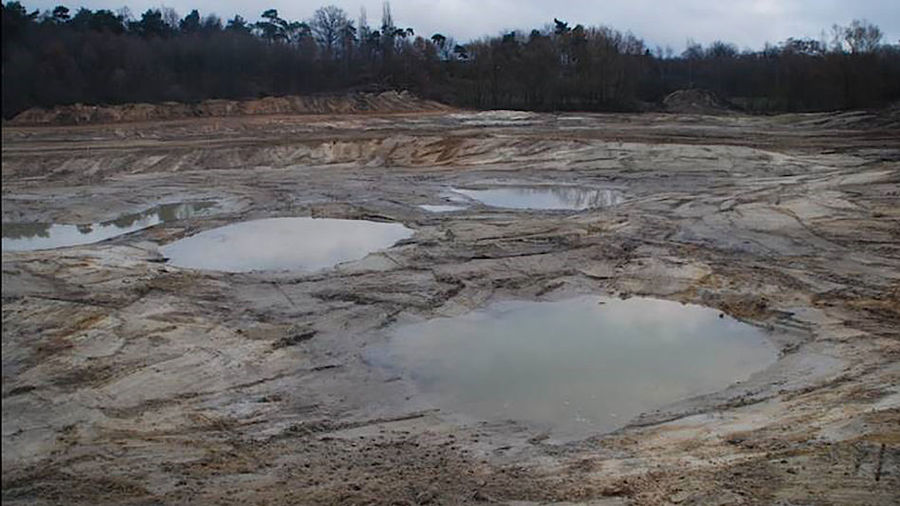
- The former sand pit Kokenger Berge Ost (owned by the company Averdam) has a strong ground relief. Part of the pit is taken by a formerly exploited quarry pond, the western part is covered with oak and birch forest. The eastern parts of the area show a semi-open landscape with small groups of taller trees. Nutrient-poor grassland vegetation and areas with open soil are just as numerous as smaller structures consisting of excavation, sorting hills and embankment edges. Several permanent waterbodies were woody or heavily overgrown with reed vegetation. The area is also interspersed with different types of small waterbodies, mostly bearing water temporarily. A peculiarity of this former sand pit is the very clayey soil in the eastern part, where an inclined clay scale was exposed by sand mining as a boundary layer. Here, 17 spawning waters with a size of about 50 square metres each were created in the framework of the LIFE IP. Three more waterbodies were restored by removing woods and bulrush. In this area, woods were also removed over a large area and transported to designated boundary areas.
- The sand pit Stunnebäke is located on the northern edge of the Damme Hills and has not been in mining as of late. Here, the landscape is still dominated by open sandy areas with lanes and higher slope edges. Nutrient-poor grassland vegetation is diverse. Woodland growth was present only at the edges of this area and as recultivation on older, already levelled and now reforested slopes. In addition to a larger, permanently water-bearing waterbody, there are temporary waterbodies such as lanes, ground depressions and soil compaction near landfills. Five of these existing small waterbodies were deepened as part of this action, and another twelve temporary or possibly permanently water-bearing small waterbodies with 50 square metres each were newly constructed. These were partly lined with clay soil, to ensure a better drainage.
- The brook valley of the Haverbeeke is part of the special areas of conservation according to the Habitats Directive and runs through partially forested and agricultural areas. The considered section has been used extensively as a pasture for more than two decades. In the east and partly in the south, it is bordered by intensively used agricultural areas; in the north, west and partly in the south, it adjoins woodland with some very old trees. The brook feeds two permanently water-bearing waterbodies in the narrow valley. The area shows a clear relief and has different microclimates and soil moisture contents at a small scale. Here, as part of the LIFE IP actions, two temporary ponds were constructed and the topsoil was stripped.
- The brook valley of the Struthbäke lies in a narrow valley cutting of the Damme Hills, surrounded by forest. It is part of the special areas of conservation according to the Habitats Directive. The area under consideration is divided into two sections separated by an intensively used agricultural area. Both sections have been used as extensive grassland for more than two decades. After entering the area, the brook feeds two small waterbodies in succession and soon afterwards seeps into the sandy soil. One of the two waterbodies was created during the LIFE project Amphikult which had been carried out by the Lower Saxony’s Nature and Biodiversity Conservation Union (NABU Niedersachsen) in winter 2015/2016. The second section of the area is not reached by the brook. So far, there has not been any waterbody there, so that a temporary water-bearing depression was created within the framework of the LIFE IP. In addition, the topsoil was stripped here as well.
- The area Nienhausen is divided into two parts and represents a larger open area used as grassland in the midst of a closed forest. It shows a vivid relief with hills and springs in the southern part where several springs of the Handorf mill brook lie. In the grassland, a total of nine ponds are scattered. The land has been used extensively for more than two decades as cattle or sheep pasture. In this area, six existing waterbodies were de-weeded and partially deepened. Three additional temporary (or possibly permanently water-bearing) small waterbodies were newly created.